uHolidays in the fresh air combined with hiking remain popular, even after the pandemic. Special providers such as Wiking Reisen have expanded their offer due to the great demand, and Christian Hlade, founder of the operator “Weltwandern” also mentions “going out into nature” as a current travel trend.
Those who appreciate peace and quiet along the way and do not want to hike the popular (and well-frequented) routes should choose paths that are less well-known. Five examples from five European countries – for families, connoisseurs or sports fans.
Germany: Adventures in the Spessart
Gangs of robbers were up to mischief in the Spessart. drives? Anyone walking near the “Hohe-Wart-Haus” forest restaurant still runs the risk of being attacked by the Mespelbrunner Spessart robbers. However, only if twelve euros per person have been paid beforehand – because the spectacle can be booked by tourists. Let’s say: for those who want something a little more special.
In Germany’s largest mixed forest area, the Spessart, important trade routes once ran that almost provoked raids from the dark undergrowth. The tourism authorities market the hiking area, which has a network of 450 kilometers of paths in northern Bavaria, as “robber country”. Vacationers hike through magnificent nature and cultural landscapes worth seeing, such as old meadow orchards.
“This is a landscape that no longer exists,” wrote the poet Kurt Tucholsky in reference to one of the most beautiful nature reserves in the area, the Hafenlohr Valley, through which the 13-kilometer “robber’s path” leads today.
Partly on boardwalks, it goes through an unspoilt swamp landscape. And if you are hungry later, you can reward yourself with the specialty of the area: the Spessart trout. Only the famous “Wirtshaus im Spessart” should not be looked for in the first place. Because that only exists in the novel of the same name by the fairy tale writer Wilhelm Hauff from 1828.
Further information: wanderbares-deutschland.de
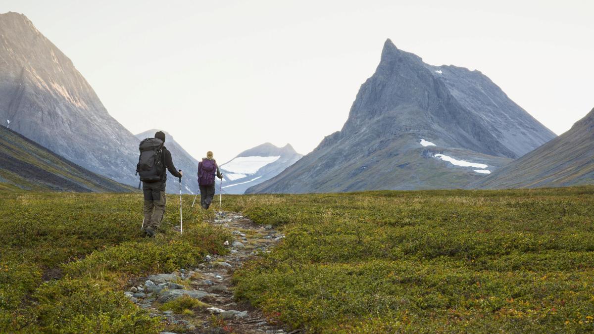
Sweden: Hiking through the wilderness in Scandinavia
Hiking in the far north – on the Kungsleden (“King’s Path”) this applies in two senses. Because Sweden’s most famous and longest hiking trail not only leads hikers through the vast wilderness beyond the Arctic Circle. Travelers also experience the impressive mountains of Lapland at over a thousand meters above sea level.
The better-known and older northern section of the Kungsleden was set up by the Swedish Hiking Association STF over 100 years ago. It leads over 440 kilometers from Abisko in the north to Hemavan in the south. Hikers should plan around a month for the entire route. The 105-kilometer section between Abisko and Nikkaluokta can also be easily completed in about a week.
A week that is worthwhile despite the expected swarms of mosquitoes and cold nights all year round: In the Abisko National Park, which is rich in lakes and water, the scenery with Sweden’s highest mountains fascinates. And if the 1150 meters of the Tjäktja Pass, which the classic hiking trail reaches at the highest point, are not enough, you can make a detour to Kebnekaise, Sweden’s highest mountain. A nearly 20-kilometer circular trail leads to the summit at 2,097 meters.
As an alternative, the separate and southern part of the Kungsleden, which connects Sälen and Storlien in central Sweden, offers a hiking experience of a special solitude class. Here, too, vacationers hike through typical Nordic landscapes with lakes and mountains, coniferous forest and mosses. And almost always alone, except for any companions. Shelters offering food for sale and cooking equipment such as those found on the northern part are non-existent here. The lonely area is ideal for savoring the Swedish right of public access: Wild camping in nature is allowed.
More information: www.svenskaturistforeningen.se
Netherlands: Historic Forts on the Waterline Path
The Dutch art of mastering the water is legendary. They have wrested large parts of the country from the sea through land reclamation, dykes protect against storm surges, their windmills were once used as pumps to drain the polders.
But the Dutch also used water for defense: if necessary, they flooded entire areas with the help of locks and dams, which were then impassable for enemies. A line of defense was built around Amsterdam as early as the 17th century, the Amsterdam Position. From 1815, this was expanded to include the New Dutch Waterline, which extends to the southern province of Noord-Brabant and is now the largest national monument in the Netherlands.
Defense technology using water was used three times in history: during the Franco-Prussian War of 1870/71, the locks were opened, then during the First World War and finally on the eve of the Second World War. The position of Amsterdam has been a UNESCO World Heritage Site since 1996, and the New Dutch Waterline was added in 2021.
If you have enough time, you can explore the impressive World Heritage Site with its numerous castles, forts, trenches, locks and canals on foot on the 350-kilometer Waterliniepad (Waterline Path). Hikers immerse themselves in exciting episodes of Dutch military and architectural history and roam through charming nature.
Interesting parts are, for example, the 13-kilometer loop around the fortified town of Woudrichem in North Brabant with the medieval moated castle of Loevestein. Or the Lint-en Liniepad over ten kilometers which leads to the trench network of Werk aan de Groeneweg and Fort Honswijk along the Lek. The Waterliniemuseum (Waterline Museum) in Bunnik nearby has exciting history(s).
More information: holland.com/de/tourist.htm
Scotland: “Harry Potter” in the Highlands
The Hogwarts Express, a train with a steam engine that takes students to Hogwarts Magic School, sets off from platform 9¾ at London’s King’s Cross, which is invisible to normal people. There are magical sweets for sale on board, and in the third installment of the Harry Potter book series, the train on the Glenfinnan Viaduct is scoured by dementors, soulless creatures with slimy hands.
Dementors and Hogwarts only exist in the novels of author Joanne K. Rowling, but the viaduct and its counterpart of the magic train also exist in the real human world. The railway bridge in the Scottish Highlands near Glenfinnan was built at the end of the 19th century on 21 pillars as one of the first concrete bridges and not only served as a backdrop for “Harry Potter”.
The Glenfinnan Viaduct Trail offers the best views of the beautiful bridge and the picturesque landscape of the Highlands. The hiking trail is particularly family-friendly because of the magic reference and the manageable length of four kilometers. Depending on the pace, the tour lasts one to two hours. Also impressive are the views over Loch Shiel, the seventh largest lake in Scotland and significant for fantasy fans because Connor MacLeod, the main character of the “Highlander” film series, was born here.
But the highlight for many is the museum train The Jacobite, which is suspiciously similar to the Hogwarts Express and steams across the viaduct up to twice a day between April and October. The Glenfinnan Viaduct Viewpoint is a particularly good place to watch The Jacobite crawling across the 30 meter high bridge. At the Glenfinnan Station Museum, visitors can dream back in time and enjoy a meal in a historic dining car, as well as information and maps for hikes.
More information: walkhighlands.co.uk/fortwilliam/glenfinnan.shtml
Albania: Storm Alpine peaks in the Balkans
Tirana is known as the capital, and perhaps the Albanian Riviera with its Caribbean-style beaches, such as those of Ksamil or Gjipe, is another bathing destination. However, it is less well known that the Balkan state even offers high mountain regions that do not need to hide from the Alps.
The southern foothills of the Dinaric Mountains are also called the Albanian Alps. They are a less frequented hiking paradise with steep mountain faces and dramatic rock towers, wide high plateaus and green alpine pastures. The village of Theth in the national park of the same name is a popular starting point for trekking and hiking tours.
A five-kilometer circular hike into the Grunas Gorge is a great way to warm up. Highlight here: the Grunas waterfall at the foot of Maja e Boshit (2414 meters). Clear meltwater pours from a height of 30 meters into a pool where bathing is permitted.
A hike from Theth over the Peja Pass (1730 meters), part of the long-distance hiking trail Peaks of the Balkans (“The Peaks of the Balkans”), which extends over mountain landscapes in Albania, Montenegro and Kosovo, offers a few more degrees of difficulty and altitude. Hikers should allow seven hours to complete the trail, which is almost 20 kilometers long and has 1,000 meters of altitude difference to overcome.
Ascents of Jezerca also start from the pass – at 2694 meters this is the highest mountain lying entirely in Albania. But the south of the country also offers high alpine delicacies for advanced skiers, such as the Korab, which is a touch higher at 2754 meters but also extends to neighboring North Macedonia.
Summiteers use the village of Radomirë in the Korab Mountains as a base camp. From there, the 16-kilometer ascent over 1,500 meters in altitude takes about nine hours. Like many other high mountain tours, it should only be undertaken with local guides. Prerequisite: physical fitness and plenty of provisions, because serviced huts are scarce in the lonely mountains of southern Albania.
For more information: peaksofthebalkans.com